Navigation: using Via Michelin for cycle touring

I guess it should not come any any great surprise that this Michelin hosted site offers pretty good navigation features.  It is well worth a look as an alternative to cycle only sites and offers a number of attractive features.

Mapping Via Michelin Style

Firstly, the mapping is very clear and attractive and its possible to selectively add several layers of information and detail.  The maps give more detail as you zoom in and offer visual cues and keys.  Good use of colour give you a sense of the terrain, but if that is not enough, then you can add satellite or map/satellite hybrids.  As far as I can see, however, no elevation view is included.  However, you can ask to add different layers of detail showing locations of eating places, hotels, etc.

A second, very positive benefit for the cycle tourer is the option to specify that you want to follow cycle suitable routes when asking for directions.  Limited testing suggests that this does not throw up cycle only routes (such as greenways etc.) but it does keep you clear of major and cycle-unfriendly roads to a degree.  As you can specify locations you want to add along the route you can fine tune routes to a degree.  Better still you can ask for locations such as petrol stations or restaurants to be added and their location appears in the item by item written instructions.  As a luxury, it will add general weather information if you ask. Once you specify a destination, its possible to search for hotels in that destination from the same page. There is a suspicion than not all hotels are shown, however, but at least this provides a decent starting point.

All this is pretty neat and convenient with an a stable site that it is pretty straightforward to navigate.  Better still its possible to export and download the route instructions as a GPX file and for different types of GPS device.

The site works well on a desktop computer or on the Apple iPad, so it seems to have something to offer  the cycle tourer at home and on the road.  Anyone got any more experience with it – for good or bad?

Check out the Via Michelin site.

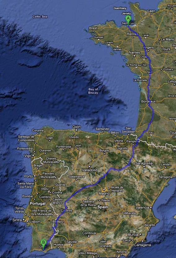
Cycle Tour Route France into Spain to Lisbon in Portugal

A poster called Meg offers this helpful route to Lisbon via Spain from France.

If you cross the border using one of the passes in Navarra and approach Pamplona and take a line roughly through Pamplona, Calahorra, Soria, Segovia, Avila, Plasencia, Caceres, cross the border at La Codosera/Marco. Then Monforte, Avis, Mora, Coruche and ferry across to Lisbon from Montijo (three bikes carried free) then you will have travelled well.

via CTC Forum • View topic – has anyone done London to Lisbon.

Cycle Touring Advice: Santandar to La Herradura, Spain

A poster called, Meg, offers this good advice for novice tourers in Spain on the CTC Site.

Re: Santandar to La Herradura, Spain

by megilleland » Mon Aug 02, 2010 11:06 pm

Has anyone got any tips for a good route and accomodation on the way?

What sort of price would I be looking at for basic b&b this year?

Horizon is right that accommodation prices have increased dramatically. The Spanish government runs its accommodation on strict guidelines and classifies them accordingly. Hotels are classified by stars, from one to five according to the facilities available. These star ratings roughly correspond to price bands, but are decided by local authorities, so standards vary slightly from place to place. Pensions and hostals are also star-classified, from one to three. All establishments have to display the standard blue sign outside their main entrance with one of the following initials to indicate (taken from Spain & Portugal for visitors):

H Hotel

Likely to be slightly more expensive and more comfortable than a hostal with the same number of stars.

HR Hotel Residencia

The word residencia means it has no restaurant or other eatery attached.

Hs Hostal

Not to be confused with a hostel as in UK, though in today’s spelling-oblivious world, most people do. A hostal is a small or smallish hotel with few or no facilities and services. Generally significantly cheaper than a hotel with the same star rating.

P Pension

Small establishments offering rooms for the night and little else, pensiones are your staple budget accommodation.

CH Casa de Huespedes

Literally, guest house, though in practice another term for pensión.

F Fonda

Like a pensión but probably also having a small restaurant or dining room.

Habitaciones/Camas

A private houseowner renting out Rooms/Beds, like a bed-and-breakfast without the breakfast. This may or may not be a legally controlled activity, if this matters to you. In a few places, you will find it is your only alternative.

Casa Rurales

Private houses offering bed and breakfast in rural areas – can be pricey.

Albergues

A hostel in the sense of basic lodgings, often with shared dormitories. They are most plentiful along Spain’s important

pilgrimage routes, the Camino de Santiago or, less so, the Vía de la Plata.

Paradores

This is a Spanish state-owned luxury or near-luxury hotel, either purpose-built or a converted castle, mansion, monastery or similar. Paradores are far from cheap but are generally excellent value for money. Check out offers through Keytel.

I stay mostly in 2 star hotels and hostals. I find these perfectly adequate – clean rooms with bath and/or shower and sensibly priced, plus they remain open 24 hours with a night porter. Above this and you are into hotels with extra facilities which you do not need, but are paying more for. In Spain you pay for the room so 20 to 30 euros isn’t too bad for two persons, but if travelling alone, you could be asked to pay for a double room – ask for a single room (habitacion sencillo). When there is little or no choice in smaller towns/large villages you can find a pension or in rare cases a fonda (rooms and meals).

I rarely eat in the establisment I am staying in, prefering to spend the evening in a bar with tapas or a small restaurant with the local residents. If the restaurant is full with locals the food is usually good. If you prefer lunch to dinner a good bargain is the “Menu del dia” providing a substantial meal usually two courses with bread, a dessert and a beverage – all for a set price.

When you book a room in a hostal you do not get breakfast. Your best and cheapest bet is to take breakfast (desayuno) in a local bar – I have fresh orange juice (zumo), toast (tostada) and marmalade (mermalada) and coffee with milk (cafe con leche) – should cost no more than 3 euros all in.

The best way to find what accommodation is available in town is to find the local Tourist Office (Oficina de Turismo) and ask for the accommodation list and street map, ask the staff for advice. The tourist office in larger towns can be open till 7pm, although in winter some will close early or altogether. Then get on your bike and quickly cycle around the town to check out the premises – ask to see the room and prices. All establishments have to display their room rates so you won’t get ripped off by paying more than you expected – there are usually two seasonal rates high and low. You can check out most establishments on the net – type in place name and the word alojamientos.

Most hostales and pensiones are on the first floor or above so you may have problems getting the tandem up the stairs.

For camping information and dates of opening check out Vayacamping.

via CTC Forum • View topic – Santandar to La Herradura, Spain.

Cycle Route out from Santander to the West and South

This is Brittany Ferries suggested route out from Santander along the coast to the West then South into the Picos de Europa.  Sounds good!

Picos and coastal cycle route details

Approximately 235 miles (total climb 15,000 feet).

A delightful but challenging route that runs a few miles inland of the coast to the west of Santander then climbs into the national park of the Picos de Europa.

The Picos stand at over 8000 feet high and three of our mountain passes are more than 1 mile above sea level. Highlights include the medieval village of Santillana del Mar, and the deep-sided gorges that lead into the Picos. Wildlife is in abundance, and if camping, you will be lulled into sleep by the sound of cowbells.

If the steep hills of the Picos are not for you, these can be missed. From Panes the route can be extended further west to take in more dramatic coastal towns and sandy beaches.

Santander to Unquera

Approximately 44 miles.

Leaving Santander is not a problem but you will need to follow the suggested route carefully. The coastal route (CA231 N611 & CA131) west of Santander to Unquera, is ideal for cyclists and is fairly low in traffic once away from Santander. This route is part of the Camino de Santiago de Compostella pilgrims’ route so you will meet many walkers on the way. If you have time or maybe fancy a dip at one of the numerous beaches, take some of the back roads off to the right to get closer to the sea. These roads have a poorer surface and are hillier than the main road but you are certainly off the beaten track here. There are plenty of options for food, hotels and campsites along the way.

The first major town, Santillana del Mar is a tourist honey pot and it’s easy to see why. This former medieval capital of Asturias has it all – cobbled streets, ancient stone houses and artisans’ shops clustered around many town squares and courtyards. It really comes alive in the cool of evening when coach loads of Spanish tourists descend. (Tourist Information Office, hotels and campsite.)

The campsite in Comillas, 10 miles west of Santillana, has an enviable position, right on the cliff top.

Approaching St Vicente de Barquera the views of the town and estuary are stunning.

It’s a pleasant town with a medieval tourist trail. Look out for the castle, an old bridge and the church which has an unusual floor made of wooden coffins. Best to be rich if buried here, as you will have prime position near the altar.

We leave the coastal road at Unquera, a town with many facilities and head south towards the Picos.

Unquera to Potes

Approximately 26 miles (total climb 1,900 feet).

The road from Unquera to Panes, the gateway to the Picos, runs along the edge of the Sierra de Cuera mountains. Our route takes us into the foothills of these mountains, through green rolling hills and the odd eucalyptus forest. For a slightly shorter, flatter but less interesting and busier route, take the N621. In Panes there are hotels but no campsite.

If the hills of the Picos are not for you, in Panes turn off onto the AS114 towards Cangas de Onis , then return towards the coast and Caravia.

From Panes there is a 15 mile steady and easy climb up a valley and the Hermida gorge. The direction of the road means it is often in full sun, which may be a problem early afternoon.

Potes, at 1,000ft is a charming town with a medieval heart, old bridges, twisting cobbled alleys and overhanging houses. There are plenty of hotels and the nearest campsite is 1mile up a hill outside the town.

If you have time for a day off from touring, cycle up to Fuente De (14 miles and 2,500 feet climb) to take the cable car to the Mirador del Cable.

Potes to Posada de Valdeón / campsite at Santa Marina

Approximately 36 miles (total climb 5,700 feet).

Today is the challenging day. There are very few hotels between Potes and Posada so it is not easy to break the journey in two. The 17 miles from Potes to the first pass at San Glorio is a steady, relentless climb of 4,250 feet. At San Glorio, you are a little over 1 mile above sea level. The first 5 miles are fairly easy but you are soon in lowest gear for the remainder, mostly on hairpin bends. There is little shade and the climb is tough, especially in full sun but the magnificent views make it worthwhile. To help you to the top you will get shouts of encouragement and gasps of admiration in equal measure from envious car drivers. There is little by way of food or water so take plenty of supplies.

From San Glorio you descend 1,000 feet alongside a river, following a delightful, wide valley of pastureland full of cows and sheep, all with tinkling bells. After the turn off onto the LE243, the gentle hill becomes steeper until you reach the Puerto de Pandetrave pass, also 1 mile high. Cars are few and far between. You are now in the middle of the Picos and the mountains are at their most dramatic.

Santa Marina de Valdeón is a wonderful, rather crumbly mountain village with nothing much going on. There is one bar/restaurant. The road to the campsite is less than a mile but incredibly steep. Still, it doesn’t stop the old ladies with amazing calf muscles clambering up with their walking sticks.

It’s cooler here in the mountains, especially at night. The campsite has good amenities, a restaurant and shop and you can fall asleep to the sound of cowbells and owls.

Alternatively, continue downhill into Posada de Valdeón where there are many hotels and restaurants. Posada is a small mountain town popular with tourists and walkers.

A spot of walking

From Posada de Valdeón, it’s well worth taking a few hours off for a detour to walk part of the magnificent Cares gorge. The start point for your walk (and finish) is in Caín, a pretty tourist village with a good choice of food and accommodation, north of Posada. You can cycle the 5 or 6 miles from Posada down to Caín but be warned, it’s a 1,500 feet return climb, tough even without luggage. The gorge lies north south so can get very hot mid day. It meanders a bit so some shade is available from time to time.

Posada de Valdeón to Cangas de Onis

Approximately 38 miles (total climb1900 feet).

From Posada, there is an easy seven mile climb which becomes quite bendy through the trees towards the top, the Puerto de Panderruedas at 4,900 feet. After a few miles down and up you reach the Puerto el Pontón. From here, the landscape becomes greener and more importantly, you can put your feet up for an exhilarating 28 mile descent. Adding a couple of layers for warmth may be a good idea at this point.

You pass through a ten-mile stretch of the Desfilladero de Beyos, a spectacular gorge with some unusual, towering rock formations. This gorge marks the western edge of the Picos. There are plenty of food and drink stops but few hotels.

Cangas is a fairly modern, large town with hotels, a tourist office and a campsite a couple of miles to the east.

Cangas de Onis to Llanes

Approximately 26 miles.

Leaving Cangas, you gently ascend the fertile valley of the Río Güeña with the foothills of the Picos to the south. After Benia and the turn off onto the AS115, you enter a long attractive valley, heavily scented with eucalyptus and pine. You may be lucky enough to spot an eagle or two to the left. If you want more of a challenge than this easy downhill stretch you can take a detour through some mountain villages to the east (your right). There are campsites in Soto de Cangas and Benia where you will also find a couple of hotels.

Llanes is a lovely old port with a vibrant market and a good Tourist Office. It is good to spend at least a few hours here so wander the old streets or consider an overnight stop. Plenty of hotels and campsites.
Cycling South out of Santander, Spain

Lot’s of online posts suggest that the cycle routes out of Santander are difficult with many main roads and the east-west motorway to be avoided.  We are planning just this journey in September 2012 and this page captures some of our planning.

An attractive option is to take the small ferry that runs from Santander on the west of the river to Pedrena on the east.  This takes you out of the busiest side of the city onto quieter roads and a cycle route to El Astillero to the south of the city. This family-made video gives an idea of the route.  Note: they are riding north to the city.

Details of the ferry crossing are available and they do take bikes.  The Santander terminus is 200 metres from the Britanny Ferries Terminus – to the east.

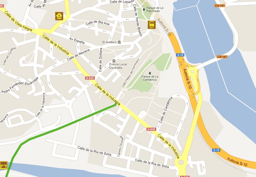
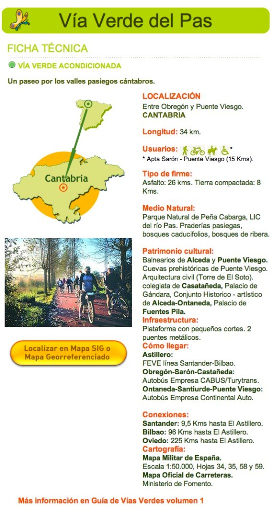
After El Astillero and going south, you can take a green way (a disused railway track) for 34K over the plain towards the Picos de Europa and Ontaneda to the south-west.

Access Point to the Greenway


 Ontaneda has a number of hotels.

Santander to Ontaneda by this route looks to be a relaxed 40-50 kilometre day.

Query:  can you cross the river back to El Astillero?

Planning: European Cyclists’ Federation – EuroVelo

I am back trying to see if I can make some sense of the Eurovelo routes, especially Route 1 North to South (Sagres in Portugal).  From the ECF Site I found this advice:

5 top tips for Planning a EuroVelo trip

“You’ve booked your leave, bought your panniers and cancelled the milk delivery but you’re still a little unsure what to do next?  Never fear; the ECF may not be a travel agency but we can give you some ideas for planning your next cycle holiday.  Set out below are our 5 top tips for ensuring that you make the most of your precious time off:

1.       Planning

Make sure that you plan your route in detail in advance.  Whilst it may sound fun to head wherever the wind takes you, such an approach can lead to difficulties – and long diversions – out on the road.  The EuroVelo Map [provide link] can be a good starting point, as this is based wherever possible on national and regional cycle routes.  The ADFC also provides useful overview information on cycle touring in different countries on their website. 

Once you have decided on which area you would like to visit, you should then plan your route in more detail.  For this type of information it is worth contacting our National EuroVelo Coordination Centres and Coordinators who often have up-to-date information on their cycle routes and in some cases have developed their own GPS information, which is available for downloading.  At the very least, they should be able to recommend a good map for the areas that you would like to visit. 

In addition, some cycle routes have their own dedicated websites, including EuroVelo 6 – Atlantic to the Black Sea and EuroVelo 12 – The North Sea Cycle Route.

It is also worth booking accommodation in advance wherever possible.  Again, our National EuroVelo Coordination Centres and Coordinators should be able to help with this.  Many have started to operate bed +bike schemes that recognise service providers that make a special effort to cater for cycle tourists (e.g. Fietsers Welkom in the Netherlands).

2.       Safety

Although a night in a foreign jail might provide some good anecdotes to tell your grandchildren, you ideally don’t want to have brushes with the law on your holidays, so be aware of the national road codes in the countries through which you are travelling.  Unfortunately, there is no one-stop-shop for this at the moment, so you will have to check country by county but the ECF’s Member Organisations [see http://www.eurovelo.org] should be able to help point you in the right direction. The European Commission also has an interactive map with road regulations in the EU27 that may be of use. 

It is also worth getting in some practice in beforehand, particularly if you do not ride regularly.  Start with some short daily rides and build up to longer weekend trips that will cover the kind of distances that you will cycle on tour.  The average cycle tourist typically covers 50-60km a day, taking into account refreshment breaks, sightseeing stops etc. 

3.       Equipment

Many of our Member Organisations [provide link] provide advice on purchasing the right equipment (e.g. CTC in the UK).  It is important to do a little research before you buy otherwise you can make an expensive mistake, which could cause you problems (and pains!), invariably when you’re miles from the nearest settlement. 

4.       Combining Bike with Train

This is the ideal combination for environmentally friendly mobility in short-and long-distance traffic. Most locations in Europe are accessible by train and by booking in advance some cheap fares can be found.  Many trains are now equipped with special bicycle areas (although unfortunately not all).  You will usually have to make a reservation in advance.

Some of the best websites for planning a train journey with your bike are Deutsche Bahn, SBB and SNCF.

5.       Keep an eye out for EuroVelo.com

Next year the ECF is hoping to develop EuroVelo.com, a public website for people who wish to cycle parts of the European cycle route network.  The website will have suggested itineraries, features on specific routes and links to further information.  You will hear about it first through the ECF website.”

via European Cyclists’ Federation – EuroVelo.

Planning: Reflections on Cycle Touring in France

In a footnote to the 2008 trip from St Malo to Tarn and Garonne, Robert Watkins, offers these interesting and helpful final thoughts.  I think I see where he is coming from.

Would we do it again? A definite yes! The idea was mooted as a pipe dream and it was due to Polly’s impetus that we actually got going with it. Her reasoning, if we wait until we’re fit, we’ll never do it, was spot on. There are things we’d change next time though. This was always going to be a one off, spending a bit of windfall cash, as it seemed unlikely that we would afford another holiday where we stayed in hotels and ate out at least once a day for a fortnight. In 2009 we’re going camping! Last year Polly wouldn’t entertain the idea of camping. That was fair enough, neither of us had done a tour like it before, so we felt the idea of doing the tour itself without the complication of taking everything needed for camping would be a stretching enough goal.What would we do differently?

We wouldn’t use chambres d’hotes. The ones we stayed in were beautiful places, Polly spent hours looking for our accommodation on the internet, but they were relatively expensive, ranging from €55 to €109 a night, they were B&Bs and at the end of the day you are staying in someone’s house not a hotel.

The food that we ate in chambres d’hotes was quite expensive compared to the cost of restaurant meals and lacked any choice. They were generally taken at one table with other guests and there’s no pleasure in having to make polite conversation in French with people with whom you’ve nothing in common and you’re not likely ever to encounter again when you’d prefer to be having your own conversation and recounting the events of the day. Then there was the small matter of how much food there was to go round. When you’ve been cycling all day, you might want to dive into the bread. No embarrassment to ask at a restaurant, a different matter, when there’s only one or two baguettes to go round the whole table. The same comments apply to breakfast, a croissant and a piece of white bread doesn’t set you up for the day.

Staying with the subject of food, we didn’t do well with our eating. Despite my comments above about the quantity of what we ate, between the two of us, we put on around a stone and a half – 21 lbs or 10kgms. That was a lot considering that we were cycling every day; obviously we were doing something wrong. Next time, we will try to resist the €12 three or four course lunch, however tempting it seems, it might be relatively cheap, but, it’s no fun cycling with a plateful of steak and chips and few glasses of wine inside you, and, it generally takes two hours. Also, we’re going to try not to over-shop at lunchtime. Buying picnic ingredients from the local shop and bread from the baker might seem superficially more economical, but realistically, what are you going to do with the rest of that whole camembert? A better option would ready made sandwiches from the boulangerie – which are only slightly more expensive.

We also made the mistake of trying not to have lunch before arriving at a certain mileage. The only way this would have been of any benefit to us would have been by cycling faster. There’s absolutely no point in saying we’re not having lunch until such and such a place if it takes until 2pm to get there. This meant that often we ate lunch with the majority of the day’s cycling completed. Next time the plan will be to buy lunch at around 11.30, eat it straight away and try to get back onto the road quite quickly to benefit from the lunchtime quietness of the roads. Somehow, I suspect that this year, we won’t have learnt the lessons from last year though!

We’re not going to entertain using unmade roads next time. On reflection, most of the D roads we used were very good. Traffic was hardly ever a problem, and they generally have very good surfaces. The other advantage of D roads is that they generally tend to go by the most direct route.

I am however, going to plan the route in roughly the same way. Each day, planned in detail on the pc, with waypoints named with a number and instruction eg. 145-L, 146-R, 147-O2, for left right and second exit at roundabout. Restricting the waypoint names to six characters means that the letters are big enough to read without glasses. This is an issue for me, long waypoint names results in tiny letters. The Garmin worked well most of the time. I had road atlas pages on my bar bag and followed those as well, but it was good not to have to stop at every junction, find glasses and the place on the map ponder and decide. Next time, I’m going to use fewer waypoints, restrict them to those that are really necessary at turns, and perhaps the odd confirmation map point after a turn. I’m using memory map to identify the summits of climbs and am putting a way point with the elevation in metres in its name. I’m not sure if this will be worthwhile, but I’ll give it a try. I’m not sure if knowing that we’ve got 700 metres of road in which to do 50 metres of climbing is going to be helpful or not.

We’re not changing the tandem this year. We’d like a new one, but it’s not this year unfortunately. We’re going to make sure it is roadworthy before we start, although we tried last year. The problem we had with the front bottom bracket could have been foreseen, and it was likely that the same problem that occurred in the rear one would sooner or later happen in the front. I didn’t think of that.

Then there were the punctures. Next year we’re not going to have any ! I have realised the mistake I made with the tubes though. I only found this out after reading an article by Leo Woodland on these pages. When we bought the tandem it had Schrader valves. I changed these to Presta, because it seemed to me to be easier, to have Presta valves on all my bikes and not to have to change the fitting on the pump. This was a mistake and probably accounted for two or three of the five punctures we had on the trip. The point Leo was making was that if your rims are drilled for Presta valves you can’t get Schraders through the hole, however, if your rims are drilled for Schrader, you can get the valve through the hole, but you shouldn’t as there’s too much wiggle room which puts strain on the valve. I have never read this or ever heard anyone say this before, but it makes eminent sense though. I’ve got myself a couple of rim adaptors that fill in the space between the hole and the valve, that and a mini track pump should help.

In conclusion, it was one of the best things we’ve done together. The weekend before we went for a meal with a couple of friends who said, ‘We’d like to have a meal with you whilst you’re still a couple’. I’m assuming they were joking! But there are many of Polly’s friends who thought she was totally mad to spend a fortnight on the back of a tandem with me. In reality, the trip has made us closer as a couple.

Taken from Robert’s Blog – an excellent account of his trip and how he went about planning it.

Planning: St Malo to Rennes Cycletrack

In St Malo go from the Britanny Ferries berth anti-clockwise round the harbour to Quaie de Dinan just by the walled city. Take the little ferry, 10 min journey, 6 euro with bike to Dinard. Find rue de la Gare. There is no Gare now but cycle/footpath along the former railway track to Dinan. The site of the former railway station is now a building site so it might take you a few minutes to find your way round it.  Follow the route towards Dinard.

When near St Samson sur Rance you leave the railway. There is a signed route via the village of Taden to the canal side path. Follow the canal d’ Ille et Rance path through Dinan and all the way to Rennes.

As an alternative to taking the small ferry, you can leave St Malo on the D201 to the south and follow this route to the canal cycleway start at Taden. (Visit Map my Ride site for full map and to download GPX File.)

If you want an alternative to the cycle track, using D roads where possible, Derek and Garry Smith did this route in 2004 and posted it into the CTC Routes site.  Looks good.

 St. Malo to Rennes, 48 miles. Pleasant, undulating countryside on quiet roads (apart from the N137).  N137 south to Chateauneuf. Then follow D337 south parallel to N137 (signed cycle-route to Rennes) via Miniac-Morvan and St Pierre de Plesguen. Here cross bridge over N137, and left to Plesder then C10 south, cross bridge over N137 and follow cycle-route signs on minor roads south via Pleugueneuc, St Domineuc, Tinteniac, and Hede. Again cross bridge over N137 and continue south on D637 via Vignoc, la Meziere, Montgermont and into Rennes. Good hotels and eating places in the attractive centre of this university town. 

More Information

With tanks to members of the Cycle Chat Forums for their ideas and contributions:

http://www.cyclechat.net/topic/96691-planning-for-france-into-spain-and-portugal/

and:

http://www.gerryotrick-cyclist.blogspot.com/

http://forum.ctc.org.uk/viewtopic.php?f=16&t=13299